 |
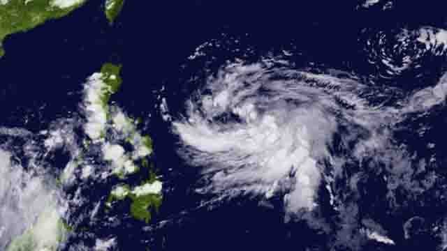
| Tropical Depression Egay poses a potential threat of becoming a super typhoon as it accelerates west-northwestward over the Philippine Sea. Photo: Himawari-8 |
TACLOBAN CITY – Tropical Depression (TD) Egay has gained strength and is on track to potentially become a supertyphoon, warns the Philippine Atmospheric, Geophysical, and Astronomical Services Administration (PAGASA). The weather bureau indicates that the tropical cyclone could intensify further within the next 12 hours, posing a potential threat to parts of the Philippines.
As of the latest update, the center of TD Egay was estimated at approximately 835 kilometers east of Southeastern Luzon, moving west-northwestward at a speed of 20 kilometers per hour. It is expected to maintain this track, passing over the Philippine Sea east of Luzon for the next few days.
PAGASA cautions that a landfall scenario over the eastern portion of mainland Cagayan and Batanes cannot be ruled out. At the same time, the current track forecast shows that Egay will likely remain offshore over the waters east of Luzon.
The weather bureau also issued a heavy rainfall outlook, with Catanduanes and Northern Samar expected to receive 50-100 mm of rainfall from Sunday afternoon to Monday afternoon.
Meanwhile, areas not directly affected by Egay may experience monsoon rains from the enhanced Southwest Monsoon, especially over the western section of MIMAROPA and Visayas on Sunday, and over the western section of Southern Luzon and Western Visayas on Monday and Tuesday.
Residents in vulnerable areas are advised to take precautions, as flooding and rain-induced landslides are possible, especially in locations identified as highly or very highly susceptible to these hazards.
Mariners of small seacrafts are also urged to exercise caution, as Egay may bring moderate to rough seas (2.0 to 3.5 meters) over the eastern seaboard of Southern Luzon and Eastern Visayas on Sunday.
Moreover, PAGASA warns that Wind Signals may be hoisted in some areas of the Bicol Region and Eastern Visayas, particularly in the eastern portion, due to possible strong breeze to gale-force conditions (up to 65 km/h) caused by Egay.
The enhanced Southwest Monsoon could also bring strong breeze to near gale conditions with intermittent gusts over MIMAROPA, Western Visayas, and western portions of Mindanao.
As the tropical cyclone continues to gain strength, Egay is forecasted to intensify into a Tropical Storm within the next 12 hours. PAGASA further advises that, throughout its duration in the PAR region, the EGAY may continue to steadily intensify and could reach the Supertyphoon category by late Monday or early Tuesday as it moves over the Philippine Sea east of Luzon.
The public is urged to stay updated with official weather advisories and heed the advice of local government units (LGUs) to ensure preparedness and safety in the face of TD Egay's potential impact. —iTacloban
